If you're a Class 10 student studying Geography Chapter-1 Resources and Development, you may be looking for quick and easy revision notes to help you prepare for exams. Our simplified notes cover all the important topics, including types of resources, sustainable development, and conservation of resources. You can also download the Resouces and Development Class 10 Notes as PDF and print it.
| Subject | Social Science (Geography) |
| Class | 10 |
| Board | CBSE and State Boards |
| Chapter No. | 1 |
| Chapter Name | Resources and Development |
| Type | Notes |
| Session | 2025-26 |
| Weightage | 4 marks |
"Education is the passport to the future, for tomorrow belongs to those who prepare for it today."
- Malcolm X
Resources and Development Class 10 Notes
Table of Contents
What are Resources?
Resources: Everything available in our environment which can be used to satisfy our needs, provided, it is
- technologically accessible,
- economically feasible and
- culturally acceptable
can be termed as a ‘Resource’.
Interdependent relationship between nature, technology, and institutions: The process of transformation of things available in our environment involves an interactive relationship between nature, technology, and institutions. Human beings interact with nature through technology and create institutions to accelerate their economic development.
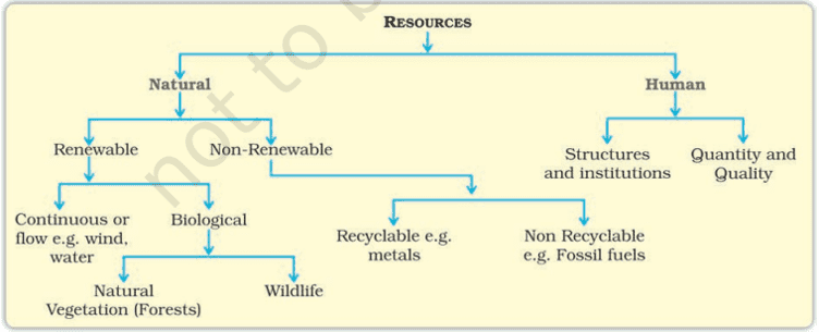
Classification of Resources
- On the basis of origin – biotic and abiotic
- On the basis of exhaustibility – renewable and non-renewable
- On the basis of ownership – individual, community, national, and international
- On the basis of the status of development – potential, developed, stock, and reserves.
Development of Resources
The problems created as a result of indiscriminate utilization of natural resources are:
- Depletion of resources at a faster rate for satisfying the greed of a few individuals.
- Accumulation of resources in few hands, as a result, dividing the society into two segments i.e., haves and have-nots or rich and poor.
- Increase in global ecological crises such as global warming, ozone layer depletion, environmental pollution, and land degradation.
Sustainable Development: Sustainable economic development means ‘development should take place without damaging the environment, and development in the present should not compromise with the needs of the future generations.’
Rio de Janeiro Earth Summit, 1992:
In June 1992, more than 100 heads of state met in Rio de Janeiro in Brazil, for the first International Earth Summit. The Summit was convened for addressing urgent problems of environmental protection and socio-economic development at the global level.
Agenda 21: Agenda 21 is the declaration signed by world leaders in 1992 at the United Nations Conference on Environment and Development (UNCED), which took place in Rio de Janeiro, Brazil. It aims at achieving global sustainable development.
The two principles are:
- To combat environmental damage, poverty, and disease through global cooperation on common interests, mutual needs, and shared responsibilities.
- Every local government should draw its own local Agenda 21.
Resource Planning
Need for resource planning
- Resource planning is a widely accepted strategy for the judicious use of resources.
- Resources in India are not evenly distributed. Some parts of the country are rich in one resource but deficient in other important resources. For example – Rajasthan is rich in solar and wind energy but lacks water resources. Jharkhand is rich in minerals and coal deposits but lacks industrialization.
- Most of the resources present in our environment are limited. Therefore, if these resources are not preserved or not used rationally we will be in great trouble.
- To reduce regional disparity.
- To save for future generations and to avoid wastage or overutilization of resources.
Three stages of resource planning
- Identification and inventory of resources across the regions of the country. This involves surveying, mapping, and qualitative and quantitative estimation and measurement of the resources.
- Evolving a planning structure endowed with appropriate technology, skill, and institutional setup for implementing resource development plans.
- Matching the resource development plans with overall national development plans.
Land Resources
India has land under a variety of relief features, namely; mountains, plateaus, plains, and islands.
- About 43% of the land area is plain, which provides facilities for agriculture and industry.
- Mountains account for 30% of the total surface area of the country and ensure the perennial flow of some rivers, providing facilities for tourism and ecological aspects.
- About 27% of the area of the country is the plateau region. It possesses rich reserves of minerals, fossil fuels, and forests.
Land Utilization
Land resources are used for the following purposes:
- Forests
- Land not available for cultivation
- Barren and wasteland
- Land put to non-agricultural uses, e.g. buildings, roads, factories, etc.
- Other uncultivated lands (excluding fallow land)
- Permanent pastures and grazing land
- Land under miscellaneous tree crops groves (not included in the net sown area)
- Culturable wasteland (left uncultivated for more than 5 agricultural years)
- Fallow lands
- Current fallow (left without cultivation for one or less than one agricultural year)
- Other than the current fallow (left uncultivated for the past 1 to 5 agricultural years)
- Net Sown Area
- the physical extent of land on which crops are sown harvested is known as the net sown area.
- Gross cropped area
- Area sown more than once in an agricultural year plus the net sown area is known as gross cropped area.
Land Use Pattern in India
Land use data is available only for 93% of the total geographical area because
- the land use reporting for most of the northeast states except Assam has not been done fully.
- Moreover, some areas of Jammu and Kashmir occupied by Pakistan and China have also not been surveyed.
33% of the geographical area should be under forest as mentioned in the National Forest Policy of 1952 because:
- it is essential for maintaining ecological balance.
- It provides a livelihood to millions of people who live on the fringes of these forests and depend upon it.
Land Degradation and Conservation Measures
- Mining: In states like Jharkhand, Chhattisgarh, Madhya Pradesh, and Odisha deforestation due to mining has caused severe land degradation.
- Overgrazing: In states like Gujarat, Rajasthan, Madhya Pradesh, and Maharashtra overgrazing is one of the main reasons for land degradation.
- Over-irrigation: In the states of Punjab, Haryana, and western Uttar Pradesh, over-irrigation is responsible for land degradation due to water logging leading to an increase in salinity and alkalinity in the soil.
Ways to Prevent Land Degradation:
- Afforestation and proper management of grazing.
- Planting of shelter belts of plants, control over grazing, and stabilization of sand dunes by growing thorny bushes are some of the methods to check land degradation in arid areas.
- Proper management of waste lands, control of mining activities, and proper discharge and disposal of industrial effluents and wastes after treatment can reduce land and water degradation in industrial and suburban areas.
Soils
Factors on which soil formation depends:
- Relief, parent rock or bedrock, climate, vegetation, and other forms of life and time are important factors in the formation of soil.
- Various forces of nature such as changes in temperature, actions of running water, wind, and glaciers, activities of decomposers, etc. contribute to the formation of soil.
- Chemical and organic changes which take place in the soil are equally important.
Classification of Soils
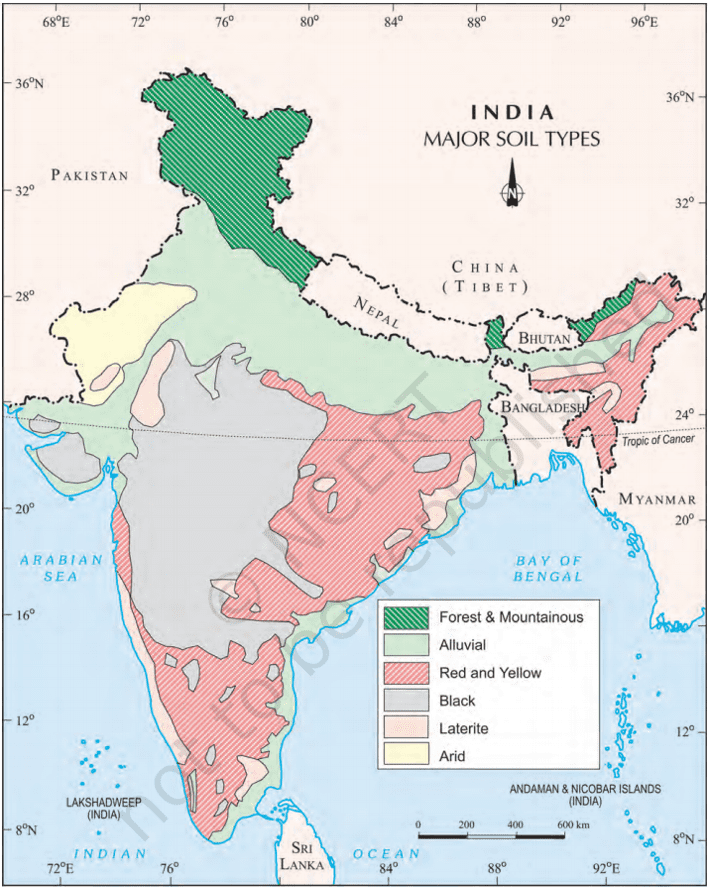
Alluvial Soils
Alluvial soil is found in the entire northern plain. It is the most widely spread soil in India.
The main features of alluvial soil are:
- It is formed by the sediments deposited by river water.
- It consists of various proportions of sand, silt, and clay.
- It is very fertile. It contains an adequate proportion of potash, phosphoric acid, and lime.
- It is ideal for the growth of sugarcane, paddy, wheat, and other cereals.
- Due to its high fertility, regions of alluvial soils are intensively cultivated and densely populated.
On the basis of age, alluvial soils can be classified into: Khadar and Bangar.
| Khadar | Bangar |
| It is a new alluvial soil. | It is an old alluvial soil. |
| Lower concentration of kankar nodules. | Higher concentration of kankar nodules. |
| It has more fine particles. | It has less fine particles. |
| It is more fertile. | It is less fertile. |
Black Soil
The following are the characteristics of regur soil (also known as black soil):
- It is made up of extremely fine clayey material. They are well-known for their capacity to hold moisture.
- It is rich in soil nutrients such as calcium carbonate, magnesium, potash, and lime.
- These soils are generally poor in phosphoric contents.
- They develop deep cracks during hot weather, which helps in the proper aeration of the soil.
- It is ideal for growing cotton, so it is also known as ‘black cotton soil’.
Red and Yellow Soil
- Red soil develops on crystalline igneous rocks in areas of low rainfall in the eastern and southern parts of the Deccan plateau.
- Yellow and red soils are also found in parts of Odisha, Chhattisgarh, southern parts of the middle Ganga plain, and along the piedmont zone of the Western Ghats.
- These soils develop a reddish color due to the diffusion of iron in crystalline and metamorphic rocks.
- It looks yellow when it occurs in a hydrated form.
Laterite Soil
- The laterite soil develops under tropical and subtropical climates with alternate wet and dry seasons.
- This soil is the result of intense leaching due to heavy rain.
- Lateritic soils are mostly deep to very deep, acidic (pH<6.0), and generally deficient in plant nutrients
- Occurs mostly in southern states, the Western Ghats region of Maharashtra, Odisha, some parts of West Bengal, and the North-east regions.
Arid Soils
- Arid soils range from red to brown in color.
- They are generally sandy in texture and saline in nature.
- In some areas, the salt content is very high, and common salt is obtained by evaporating the water.
- Due to the dry climate, and high temperature, evaporation is faster and the soil lacks humus and moisture.
Forest Soils
- They are loamy and silty on valley sides and coarse-grained on the upper slopes.
- In the snow-covered areas of the Himalayas, these soils experience denudation and are acidic with low humus content.
- The soils found in the lower parts of the valleys, particularly on the river terraces and alluvial fans are fertile.
Soil Erosion and Soil Conservation
Soil erosion is the displacement of the upper layer of soil, caused by various agents such as water, wind, and human activities. This can lead to loss of fertile land, reduced crop yields, and increased risk of landslides and flooding.
Types of soil erosion:
- Gullies: The running water cuts through the clayey soil and makes deep channels/gullies. The unfit land caused by gullies is called bad land or ravines (bad land called ravine in the Chambal basin).
- Sheet erosion: Water flows as a sheet over large areas down a slope. The topsoil is washed away. This process is known as sheet erosion.
Causes of soil erosion:
- Human activities like deforestation, over-grazing, construction, mining, etc. are responsible for soil erosion.
- Natural forces like wind, glaciers, and water also lead to soil erosion. Running water cuts through the clayey soil and makes deep channels known as gullies, which makes the land unfit for cultivation. The wind blows loose soil off flat or sloping land known as wind erosion.
- Soil erosion is also caused due to defective methods of farming. Ploughing in the wrong way i.e., up and down the slope forms channels for the quick flow of water leading to soil erosion.
Measures to prevent soil erosion:
- Contour ploughing: Ploughing along the contour lines can decrease the speed of water flow down the slopes and soil erosion can be prevented.
- Terrace cultivation: Step or terrace cultivation on slopes restricts erosion. Western and Central Himalayas have well-developed terrace farming.
- Strip cropping: Large fields can be divided into strips and strips of grass are left to grow between the crops. This breaks up the force of the wind and prevents soil erosion.
- Shelter belts: Rows of trees called shelter belts have led to the stabilization of sand dunes in the desert in western India.
| Must Read: Resources and Development Class 10 Important Questions and Answers Class 10 Revision Notes Class 10 Important Questions Map work for Class 10 SSt 2025-26 |


Hope you liked these Notes on Resources and Development Class 10. Please share this with your friends and do comment if you have any doubts/suggestions to share.
Related posts:
 Class 10
Print Culture and the Modern World Class 10: Important Questions, Easy Answers
Acids, Bases and Salts Class 10 Important Questions and Answers
Federalism Class 10 Most Important Questions and Answers
Manufacturing Industries: Demystified with Class 10 Questions and Answers
Class 10
Print Culture and the Modern World Class 10: Important Questions, Easy Answers
Acids, Bases and Salts Class 10 Important Questions and Answers
Federalism Class 10 Most Important Questions and Answers
Manufacturing Industries: Demystified with Class 10 Questions and Answers
 CBSE Class 10 Maths Sample Paper: Exam Setup, Question Types & Solutions
Life Processes Class 10 Notes: Simplified and Easy to Understand
The Thief’s Story Class 10: Top Questions and Answers for Exam Preparation
CBSE Class 10 Maths Sample Paper: Exam Setup, Question Types & Solutions
Life Processes Class 10 Notes: Simplified and Easy to Understand
The Thief’s Story Class 10: Top Questions and Answers for Exam Preparation
Sir you are the best on youtube that teach us very effeciently and along with important questions. I secured 85% only by your teaching but sir you have to complete all the chapters so we dont need to go any other channels for studying remaining chapters. THANK YOU SIR
Sir, can u please help how to cope up with English Grammar topics , Hindi and social studies in less time
Why in less time? There is enough time for 2025-26 board exams. Take you sweet time and learn concepts.
hello great teachers if i learn only the simplified notes of ur every lessson its enough for term end exams along with reading the testbook? also are these notes based on the rationalized book because data is different now for the batch 25-26 . much love pls dont stop making these
Yes these notes are enough. Also try to go through the provided important questions & answers. And yes these notes are based on the rationalized ncert book. And I constantly updates these notes and questions answers to include up-to-date information.
Sir your notes as well as teaching skills are outstanding
hi you are a abhinav