Get all important questions with answers from Chapter 1 Resources and Development (Class 10 Geography) here. These important and extra questions are compiled by CBSE Guidance from CBSE Official Sample Papers, CBSE PYQs, and other sources. Students must prepare these questions to score maximum in their exams.

| Subject | Social Science (Geography) |
| Class | 10 |
| Board | CBSE and State Boards |
| Chapter No. | 1 |
| Chapter Name | Resources and Development |
| Type | Important Questions and Answers |
| Session | 2025-26 |
| Weightage | 4 marks |
"Don't watch the clock; do what it does. Keep going."
- Sam Levenson
Resources and Development Class 10 Important Questions and Answers
Q. No. 1) Multiple Choice Questions (MCQs)
i. Sharanya is making a list of natural resources for a project. She puts wind energy under one column and coal under another column. On what basis is she classifying the resources?
a. On the basis of origin
b. On the basis of ownership
c. On the basis of exhaustibility
d. On the basis of the status of development
Ans. Option (c)
ii. Match the following:
| Resources | Examples |
| A. Renewable resources | I. Forest and wildlife |
| B. Non-renewable resources | II. The oceanic resources |
| C. National resources | III. Roads, canals, and railway |
| D. International resources | IV. Minerals and fossil fuels |
Options
a. A-I, B-IV, C-III, D-II
b. A-II, B-I, C-IV, D-III
c. A-IV, B-I, C-IV, D-II
d. A-I, B-IV, C-II, D-III
Ans. Option (a).
iii. India’s territorial water extends up to a distance of ____.
a. 12 km
b. 12 nautical miles
c. 19.2 miles
d. 200 nautical miles
Ans. Option (b) [12 nautical miles or 22.2 km]
iv. The ocean resources beyond 200 nautical miles are classified under which zone?
a. Exclusive Economic Zone
b. Export Processing Zone
c. Special Economic Zone
d. None of these
Ans. Option (a)
v. Which one of the following conferences was convened to discuss environmental protection and socio-economic development at the global level in 1992?
a. Kyoto Protocol
b. Montreal Protocol
c. Rio de Janeiro Earth Summit
d. World Summit on Sustainable Development
Ans. Option (c)
vi. What is the aim of Agenda 21?
a. Technological development
b. Globalization
c. Economic development
d. Global sustainable development
Ans. Option (d)
vii. Which relief feature of India has 30% of the total surface area of the country?
a. Plateau
b. Mountain
c. Plain
d. Desert
Ans. Option (b)
viii. What percentage of land in India consists of fertile plains?
a. 70 %
b. 38 %
c. 61 %
d. 43 %
Ans. Option (d)
ix. Which of the following relief features of India possess the highest reserves of minerals and fossil fuels?
a. Coastal plain
b. Gangetic plain
c. Shivalik mountains
d. Chotanagpur plateau
Ans. Option (d)
x. Read the passage given below and answer the question that follows:
Jharkhand, Chhattisgarh, and Madhya Pradesh are rich in mineral deposits. Arunachal Pradesh has abundant water resources but lacks infrastructural development. Rajasthan is endowed with solar and wind energy but lacks water resources. The cold desert of Ladakh has a rich cultural heritage but it is deficient in water and infrastructure.
Which of the following BEST describes the passage?
a. All regions in India are economically self-sufficient to utilize resources.
b. Only Rajasthan has the scope to utilize renewable resources.
c. India has enormous diversity in the availability of resources.
d. Resource diversity is prevalent only in north India.
Ans. Option (c).
xi. The land which is left uncultivated for one or less than one agricultural year is called _____.
a. Culturable wasteland
b. Current fallow land
c. Net sown area
d. Gross cropped area
Ans. Option (b)
xii. The piece of land left uncultivated for more than 5 agricultural years is called _____.
a. Barren land
b. Forest land
c. Grazing land
d. Culturable waste land
Ans. Option (d)
xiii. Which one of the following is an example of a Cultivable Wasteland?
a. Gross cropped area
b. Uncultivable land
c. Barren wasteland
d. Current fallow land
Ans. Option (b).
xiv. Forest area in the country is far lower than the desired _____ percent of geographical area, as it was outlined in the National Forest Policy, 1952.
a. 24.43
b. 33
c. 30
d. 35
Ans. Option (b)
xv. India has land under a variety of relief features. Which of the following features ensure the perennial flow of some rivers, and provide facilities for tourism and ecological aspects?
a. Plains
b. Plateaus
c. Islands
d. Mountains
Ans. Option (d).
xvi. Continuous use of land over a long period of time without taking appropriate measures results in _____.
a. Land degradation
b. Soil erosion
c. Loss of soil nutrients
d. Denudation
Ans. Option (a)
xvii. Overgrazing is one of the main reasons for land degradation in the following states.
a. Punjab, Haryana, Western Uttar Pradesh
b. Maharashtra and Gujarat
c. Gujarat, Rajasthan, MP, Maharashtra
d. Maharashtra and Uttar Pradesh
Ans. Option (c)
xviii. In which of the following states, deforestation caused land degradation due to mining?
a. Kerala
b. Punjab
c. Odisha
d. Rajasthan
Ans. Option (c) [In states like Jharkhand, Chhattisgarh, Madhya Pradesh, and Odisha deforestation due to mining is the main cause of land degradation.]
xix. Name the soil which is most widely spread in India.
a. Alluvial
b. Laterite
c. Black
d. Mountainous soil
Ans. Option (a)
xx. Name the soil which is generally poor in Phosphoric contents.
a. Mountain soil
b. Red soil
c. Black soil
d. Laterite soil
Ans. Option (c)
xxi. Which soil is also known as regur soil?
a. Black soil
b. Red soil
c. Alluvial soil
d. Laterite soil
Ans. Option (a)
xxii. Identify the soil with the help of clues given below:
- Develops in areas with high temperatures and heavy rainfall
- Is low in humus content
- Found in the hilly areas of Karnataka, Kerala, and Tamil Nadu
Options
a. Forest soil
b. Yellow soil
c. Black soil
d. Laterite soil
Ans. Option (d) [Also remember the above features of laterite soil]
xxiii. By which name is the bad land in the Chambal basin known?
a. Fallow land
b. Ravines
c. Gullies
d. Wasteland
Ans. Option (b)
xxiv. What contributes to the stabilization of sand dunes in western India?
a. Shelter belts
b. Strip cropping
c. Terrace farming
d. Contour ploughing
Ans. Option (a)
xxv. Match the following efforts of resource conservation from column A with years from column B.
| Column A (Resource Conservation Efforts) | Column B (Years) |
| A. The Club of Rome advocated resource conservation | i. 1992 |
| B. Gandhian Philosophy presented in "Small is Beautiful" | ii. 1987 |
| C. Brundtland Commission Report on "Sustainable Development" | iii. 1974 |
| D. Earth Summit at Rio de Janeiro | iv. 1968 |
a. A-ii, B-iv, C-i, D-iii
b. A-iv, B-iii, C-i, D-ii
c. A-iv, B-iii, C-ii, D-i
d. A-ii, B-iv, C-iii, D-i
Ans. Option (c)
xxvi. Match the items in Column A with that in Column B.
| Column A | Column B |
| A. Potential | i. Solar Energy |
| B. Stock | ii. Ponds |
| C. Individual | iii. Wind energy in Rajasthan |
| D. Renewable | iv. Hydrogen |
a. A-II, B-IV, C-I, D-III
b. A-III, B-IV, C-II, D-I
c. A-III, B-I, C-IV, D-II
d. A-I, B-III, C-II, D-IV
Ans. Option (b)
xxvii. There are two statements given below, marked as Assertion (A) and Reason (R). Read the statements and choose the correct option.
- Assertion (A): Resource planning is a complex process.
- Reason (R): Resource planning helps in the effective and judicious use of resources.
Options
a. A is true but R is false
b. A is false but R is true
c. Both A and R are true and R explains A
d. Both A and R are true but R does not explain A
Ans. Option (d)
Q. No. 2) Identify the soil with the help of the following features.
- Red to brown in color
- Sandy in texture and saline in nature
- Lacks humus and moisture
- Develops due to high temperature and evaporation
Ans. Arid soil. [*Also remember the above features of arid soil. Questions can be asked like this: Mention any 3 features of arid soil.]
Q. No. 3) Identify the soil with the help of the following features.
- It consists of various proportions of sand, silt, and clay.
- Soil particles appear somewhat bigger in size when we move closer to the river valley.
- Such soils are more common in piedmont plains such as Duars, Chos, and Terai.
Ans. Alluvial soil. [*Also remember the above features of alluvial soil. Questions can be asked like this: Mention any 3 features of alluvial soil.]
Q. No. 4) Identify the soil with the help of the following features.
- It develops under tropical and subtropical climates with an alternate wet and dry season.
- Mostly deep to very deep, acidic, and generally deficient in plant nutrients.
- It is humus-rich, but under sparse vegetation and in a semi-arid environment, it is generally humus poor.
- They are prone to erosion.
Ans. Laterite soil. [*Also remember the above features of the soil. Questions can be asked like this: Mention any 3 features of laterite soil.]
Q. No. 5) Define resources.
Ans. Everything available in our environment which can be used to satisfy our needs, provided, it is technologically accessible, economically feasible, and culturally acceptable can be termed as a ‘Resource’.
Q. No. 6) Explain the classification of resources on the basis of origin.
Ans. Classification of resources on the basis of origin:
- Biotic resources
- Abiotic resources
Q. No. 7) Classify the resources on the basis of exhaustibility.
Ans. Renewable and Non-renewable resources.
Q. No. 8) Provide a suitable classification of resources on the basis of ownership.
Ans. Classification of resources on the basis of ownership:
- Individual resources
- Community-owned resources
- National resources
- International resources
Q. No. 9) Examine the major problems created as a result of the indiscriminate utilization of natural resources. How can this situation be averted?
Ans. The problems created as a result of indiscriminate utilization of natural resources are:
- Depletion of resources at a faster rate for satisfying the greed of a few individuals.
- Accumulation of resources in few hands, as a result, dividing the society into two segments i.e., haves and have-nots or rich and poor.
- Increase in global ecological crises such as global warming, ozone layer depletion, environmental pollution, and land degradation.
Ways to avoid this situation:
- Judicious use of resources should be done keeping in mind the need of the present and future.
- There should be equal distribution and sharing of resources so that everyone gets desired benefits.
- Resource planning should be done.
- We should divert ourselves to the use of non-conventional sources.
Q. No. 10) What is Agenda 21? List its two principles.
Ans. Agenda 21 is the declaration signed by world leaders in 1992 at the United Nations Conference on Environment and Development (UNCED), which took place in Rio de Janeiro, Brazil. It aims at achieving global sustainable development.
The two principles are:
- To combat environmental damage, poverty, and disease through global cooperation on common interests, mutual needs, and shared responsibilities.
- Every local government should draw its own local Agenda 21.
Q. No. 11) Why is resource planning essential?
Or,
What is the need of doing resource planning in a country like India?
Ans. Resource planning is essential because:
- Resource planning is a widely accepted strategy for the judicious use of resources.
- Resources in India are not evenly distributed. Some parts of the country are rich in one resource but deficient in other important resources. For example – Rajasthan is rich in solar and wind energy but lacks water resources. Jharkhand is rich in minerals and coal deposits but lacks industrialization.
- Most of the resources present in our environment are limited. Therefore, if these resources are not preserved or not used rationally we will be in great trouble.
- To reduce regional disparity.
- To save for future generations and to avoid wastage or overutilization of resources.
Q. No. 12) What are the three stages of resource planning?
Ans. The three stages of resource planning are:
- Identification and inventory of resources across the regions of the country. This involves surveying, mapping, and qualitative and quantitative estimation and measurement of the resources.
- Evolving a planning structure endowed with appropriate technology, skill, and institutional setup for implementing resource development plans.
- Matching the resource development plans with overall national development plans.
Q. No. 13) Write any three human activities which are responsible for land degradation in India.
Ans. Three human activities responsible for land degradation in India are:
- Mining: Expansion of mining and quarrying have contributed significantly to land degradation. In Jharkhand, Chhattisgarh, Madhya Pradesh, and Orissa deforestation due to mining have caused severe land degradation.
- Over-grazing: In states like Gujarat, Rajasthan, Madhya Pradesh, and Maharashtra overgrazing is one of the main reasons for land degradation
- Over-irrigation: In the states of Punjab, Haryana, and western Uttar Pradesh, over-irrigation is responsible for land degradation due to water logging leading to an increase in salinity and alkalinity in the soil.
- Mineral processing like the grinding of limestone for the cement industry and calcite and soapstone for the ceramic industry generates huge quantities of dust in the atmosphere. It retards the process of infiltration of water into the soil after it settles down on the land.
Q. No. 14) Suggest and explain ways to protect the land from degradation in various states of India.
Or,
Describe any three measures of controlling land degradation.
Ans. Measures to control land degradation:
- Afforestation and proper management of grazing should be done.
- Planting of shelter belts of plants and control over grazing should be done.
- Stabilization of sand dunes by growing thorny bushes.
- Control of mining activities and proper management of waste lands should be done.
- Proper discharge and disposal of industrial effluents and wastes after treatment.
Q. No. 15) Explain the various purpose of land use.
Ans. Land resources are used for the following purposes:
i. Forests
ii. Land not available for cultivation
- Barren and wasteland
- Land put to non-agricultural uses, e.g. buildings, roads, factories, etc.
iii. Other uncultivated lands (excluding fallow land)
- Permanent pastures and grazing land
- Land under miscellaneous tree crops groves (not included in the net sown area)
- Culturable wasteland (left uncultivated for more than 5 agricultural years)
iv. Fallow lands
- Current fallow (left without cultivation for one or less than one agricultural year)
- Other than the current fallow (left uncultivated for the past 1 to 5 agricultural years)
v. Gross cropped area
Area sown more than once in an agricultural year plus the net sown area is known as gross cropped area.
Q. No. 16) Study the pie diagram representing the land use data of India for the year 1960-61 & 2014-15 and answer the following questions:
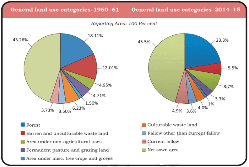
a. Mention the percentage of land under the net sown area in 1960-61 & 2014-15 respectively.
b. Why maximum share of land is under Net Sown Area in India? Give two reasons.
c. State why 33 % of the geographical area should be under forest as mentioned in the National Forest Policy of 1952. Give two reasons.
Ans. a.
- 1960-61: 45.26%
- 2014-15: 45.5%
b. Maximum share of land is under the net sown area in India because:
- The growing food demand to feed the growing population of India is responsible for the maximum share of land under the net sown area.
- To achieve food security the share of land under the net sown area is more.
c. The reasons are:
- 33 % of the geographical area should be under forest as it is essential for maintaining ecological balance.
- It provides a livelihood to millions of people who live on the fringes of these forests and depend upon it.
Q. No. 17) What type of soil is found in the river deltas of the eastern coast? Give four main features of this type of soil.
Ans. Alluvial soil is found in the entire northern plain. It is the most widely spread soil in India.
The main features of alluvial soil are:
- It is formed by the sediments deposited by river water.
- It consists of various proportions of sand, silt, and clay.
- It is very fertile. It contains an adequate proportion of potash, phosphoric acid, and lime.
- It is ideal for the growth of sugarcane, paddy, wheat, and other cereals.
- Due to its high fertility, regions of alluvial soils are intensively cultivated and densely populated.
Q. No. 18) Classify alluvial soil on the basis of age and differentiate between them.
Or,
Distinguish between Khadar and Bangar soil.
Ans. According to age, alluvial soils can be classified as old alluvial (Bangar) and new alluvial (Khadar).
| Khadar | Bangar |
| i. It is a new alluvial soil. | i. It is an old alluvial soil. |
| ii. Lower concentration of kankar nodules. | ii. Higher concentration of kankar nodules. |
| iii. It has more fine particles. | iii. It has less fine particles. |
| iv. It is more fertile. | iv. It is less fertile. |
Q. No. 19) Write the features of ‘regur’ soil.
Ans. The following are the characteristics of regur soil (also known as black soil):
- It is made up of extremely fine clayey material. They are well-known for their capacity to hold moisture.
- It is rich in soil nutrients such as calcium carbonate, magnesium, potash, and lime.
- These soils are generally poor in phosphoric contents.
- They develop deep cracks during hot weather, which helps in the proper aeration of the soil.
- It is ideal for growing cotton, so it is also known as ‘black cotton soil’.
Q. No. 20) Distinguish between red and laterite soils.
Ans.
| Red soil | Laterite soil |
| i. Formed due to the weathering of igneous and metamorphic rocks. | i. Formed by the leaching process. |
| ii. Develop in areas of low rainfall. | ii. Develop in areas of high rainfall. |
| iii. Red in color due to the presence of iron in them. | iii. Red in color due to little clay and much gravel of red sandstones |
| iv. These are less crystalline. | iv. These are crystalline. |
| v. These are highly porous and less fertile, but where these are deep, these are fertile. | v. These are less fertile, only grass grows in abundance. |
Q. No. 21) Define soil erosion. Explain the two types of soil erosion mostly observed in India. What are the causes of soil erosion in India?
Ans. Soil erosion is the displacement of the upper layer of soil, caused by various agents such as water, wind, and human activities. This can lead to loss of fertile land, reduced crop yields, and increased risk of landslides and flooding.
Types of soil erosion:
- Gullies: The running water cuts through the clayey soil and makes deep channels/gullies. The unfit land caused by gullies is called bad land or ravines.
- Sheet erosion: Water flows as a sheet over large areas down a slope. The topsoil is washed away. This process is known as sheet erosion.
Causes of soil erosion:
- Human activities like deforestation, over-grazing, construction, mining, etc. are responsible for soil erosion.
- Natural forces like wind, glaciers, and water also lead to soil erosion. Running water cuts through the clayey soil and makes deep channels known as gullies, which makes the land unfit for cultivation. The wind blows loose soil off flat or sloping land known as wind erosion.
- Soil erosion is also caused due to defective methods of farming. Ploughing in the wrong way i.e., up and down the slope forms channels for the quick flow of water leading to soil erosion.
Q. No. 22) What are the factors that have contributed to the development of various types of soils in India? Suggest any three methods through which soil erosion can be prevented.
Or,
Suggest any three methods of soil conservation suitable to Indian conditions.
Or,
What steps can be taken to control soil erosion in hilly areas?
Ans. India has varied relief features, landforms, climatic reals, and vegetation types which have contributed to the development of various types of soils.
Measures to prevent soil erosion:
- Contour ploughing: Ploughing along the contour lines can decrease the speed of water flow down the slopes and soil erosion can be prevented.
- Terrace cultivation: Step or terrace cultivation on slopes restricts erosion. Western and Central Himalayas have well-developed terrace farming.
- Strip cropping: Large fields can be divided into strips and strips of grass are left to grow between the crops. This breaks up the force of the wind and prevents soil erosion.
- Shelter belts: Rows of trees called shelter belts have led to the stabilization of sand dunes in the desert in western India.
| Must Read: Resources and Development Class 10 Notes Class 10 Revision Notes Class 10 Important Questions |


Hope these questions were helpful to you in preparing this chapter for your exams. Please share this with your friends and do comment on your doubts/suggestions in the comment section below.
Related posts:
 Class 10
Print Culture and the Modern World Class 10: Important Questions, Easy Answers
Acids, Bases and Salts Class 10 Important Questions and Answers
Crack Metals and Non-metals Class 10 Important Q&A
Globalization and the Indian Economy: Class 10 Important Questions & Answers
Class 10
Print Culture and the Modern World Class 10: Important Questions, Easy Answers
Acids, Bases and Salts Class 10 Important Questions and Answers
Crack Metals and Non-metals Class 10 Important Q&A
Globalization and the Indian Economy: Class 10 Important Questions & Answers
 15/03/2023 CBSE Class 10 Social Science Answer key
Class 10 Social Science: The Rise of Nationalism in Europe Notes
Nelson Mandela: Long Walk to Freedom: Class 10 Q&A
15/03/2023 CBSE Class 10 Social Science Answer key
Class 10 Social Science: The Rise of Nationalism in Europe Notes
Nelson Mandela: Long Walk to Freedom: Class 10 Q&A
Sir pls upload manufacturing industries
Okay I will do it soon.
Sir upload metals and non metals as soon as possible..
Okay
Good evening sir, Sir please Public the video of SST which you did private on You Tube Channel
Sir please help in english
Sir, this had been very helpful to me. Please upload important questions of all chapters of social science and science.
So nice to hear that from you. Yes I am actively working on it.
Sir I have doubt in xxv MCQ
I think it is wrong…
Yes I have corrected it. Thanks for sharing.
Welcome 🤗 sir
Hi sir
Sir I think it’s again wrong bcz in Q.No.9) stock is hydrogen
Potential is Rajasthan wind
Plz sir reply fast I am waiting
Yes, I have now changed Option (b). There was some typing mistake.
Sir your all videos and Q/A are best . Please come live on YouTube for some doughts
Sir in the difference between Bangar and Kharar as the second point is not correct
Hii sir
Hello sir
Iam study from up board
So iam not read ncert because it was very difficult and how to make simple concept and iam not already study the ncert
For easy and detailed explanation of NCERT book, please watch my youtube channel ‘CBSE Guidance’.
sir pdf link nhi hai fir bhi maine text copy karke pdf converter app se pdf bna liya ab any time revision krunga
sir can you please upload pdf of this
How to Download PDF from CBSE Guidance Website
https://youtu.be/zjocgf0LzUM
this is very helpful
thank you so much sir very helpful
do some previous year question from CBSE and repeated questions in board pls sir
Sir 27 th answer wrong. so check
It is the right answer.