
These map items cover the entire syllabus of Class 10 Social Science (SST) and help students prepare for their CBSE Board exam 2026-27. The weightage of map work in the CBSE class 10 board exam is 05 marks out of a total of 80 marks.
| Class | 10 |
| Board | CBSE and State Boards |
| Subject | Social Science (SSt) |
| Type | Map Items (Map work) |
| Weightage | 05 marks (02-History & 03-Geography) |
| Session | 2026-27 |
Being prepared for the CBSE Board exam 2026-27 can be a challenging task, especially in the Class 10 Social Science (SST) course. To help students build a strong foundation for their board exams, here is a comprehensive list of map items that cover the entire syllabus for this course.
Syllabus of Map Work Class 10 2026-27
History
| Chapters | Map Items |
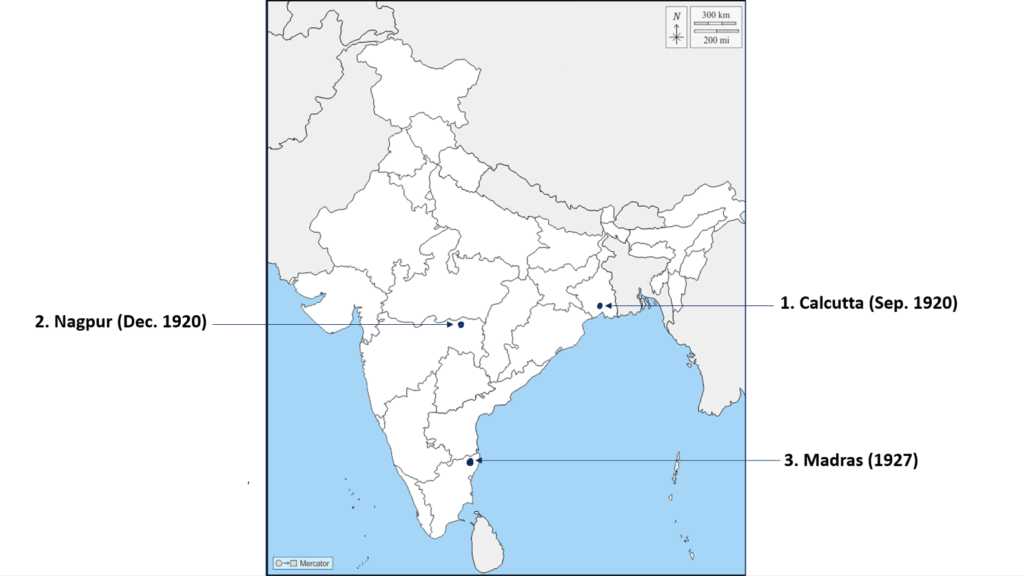
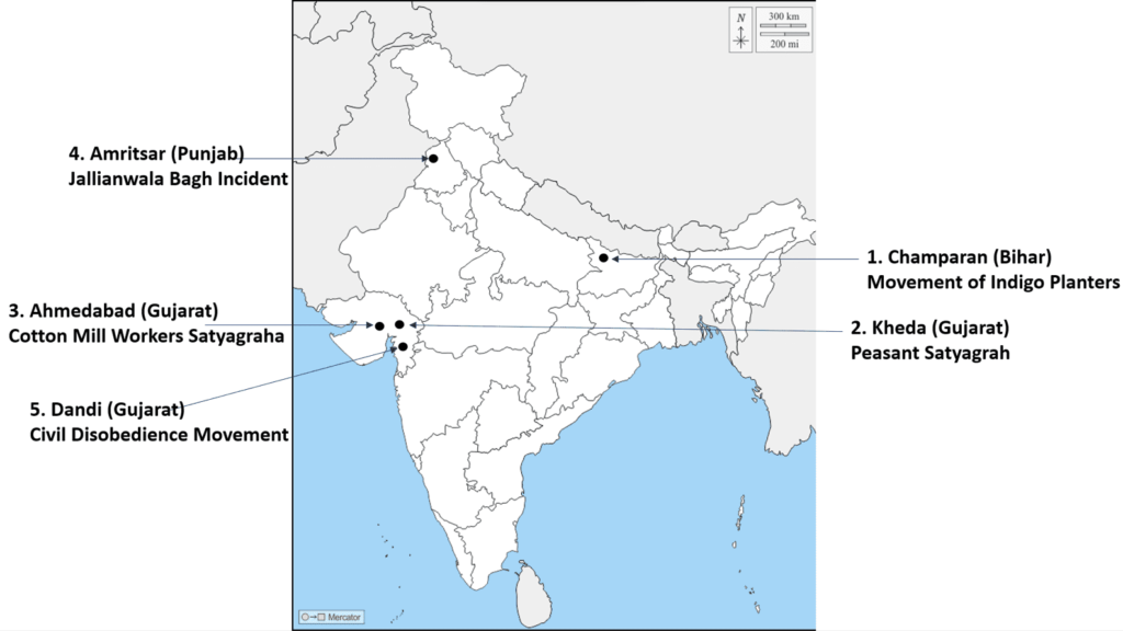
| Chapter - 2 Nationalism in India (1918-1930) | Locating and Labeling / Identification 1. Indian National Congress Sessions: a. Calcutta (Sep. 1920) b. Nagpur (Dec. 1920) c. Madras (1927) 2. Important Centres of Indian National Movement a. Champaran (Bihar) - Movement of Indigo Planters b. Kheda (Gujarat) - Peasant Satyagrah c. Ahmedabad (Gujarat) - Cotton Mill Workers Satyagraha d. Amritsar (Punjab) - Jallianwala Bagh Incident e. Dandi (Gujarat) - Civil Disobedience Movement |
Geography
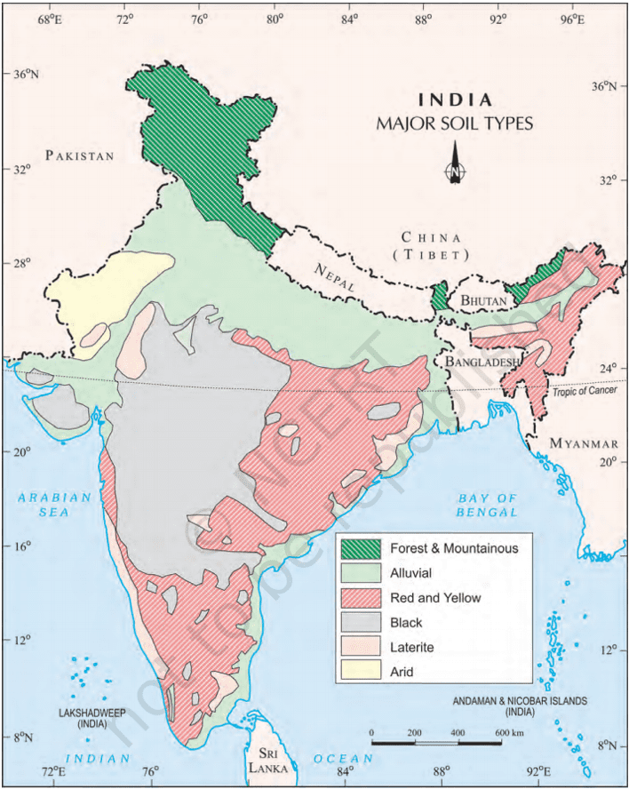
| Chapter 1: Resources and Development | (Identification only) a. Major soil Types |
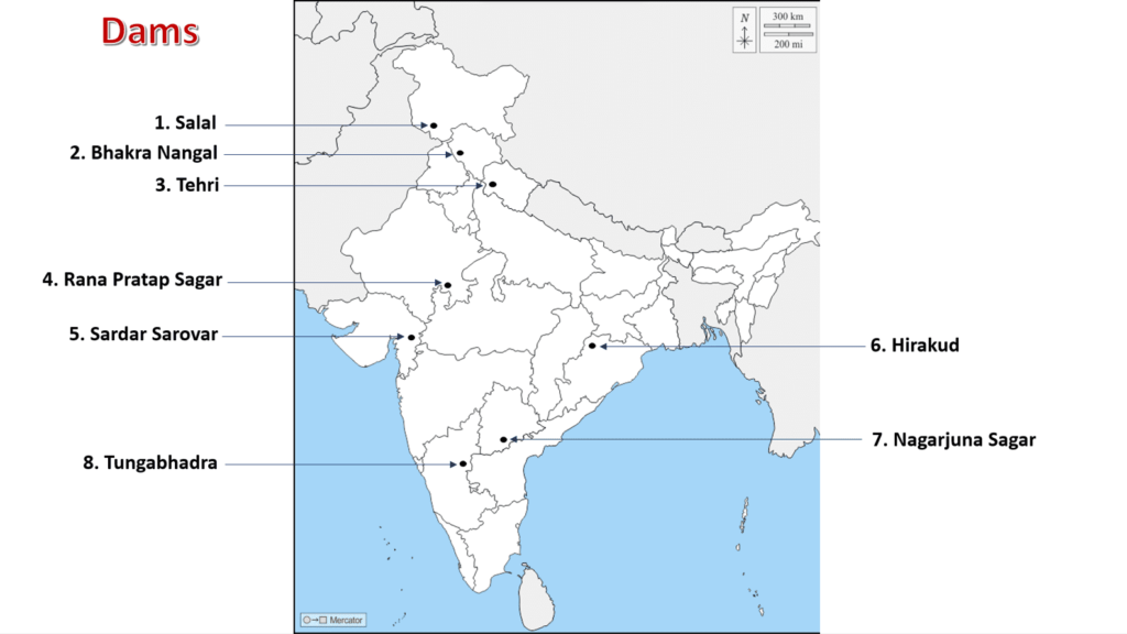
| Chapter 3: Water Resources | (Locating and Labelling) Dams: a. Salal b. Bhakra Nangal c. Tehri d. Rana Pratap Sagar e. Sardar Sarovar f. Hirakud g. Nagarjuna Sagar h. Tungabhadra |
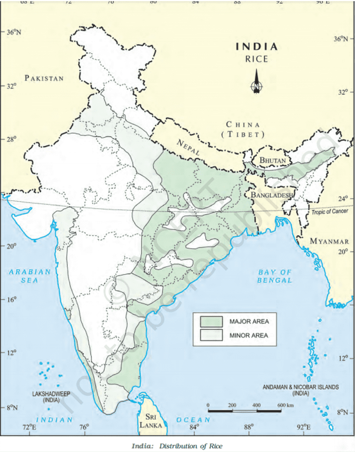
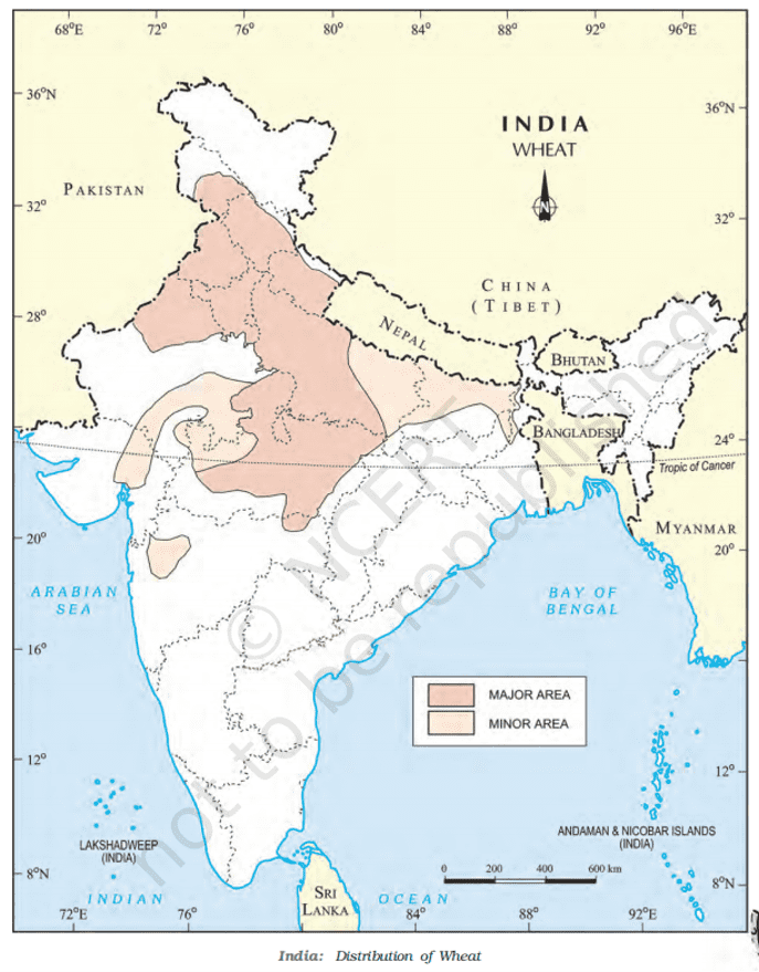
| Chapter 4: Agriculture | (Identification only) a. Major areas of Rice and Wheat b. Largest/Major producer states of Sugarcane, Tea, Coffee, Rubber, Cotton, and Jute |
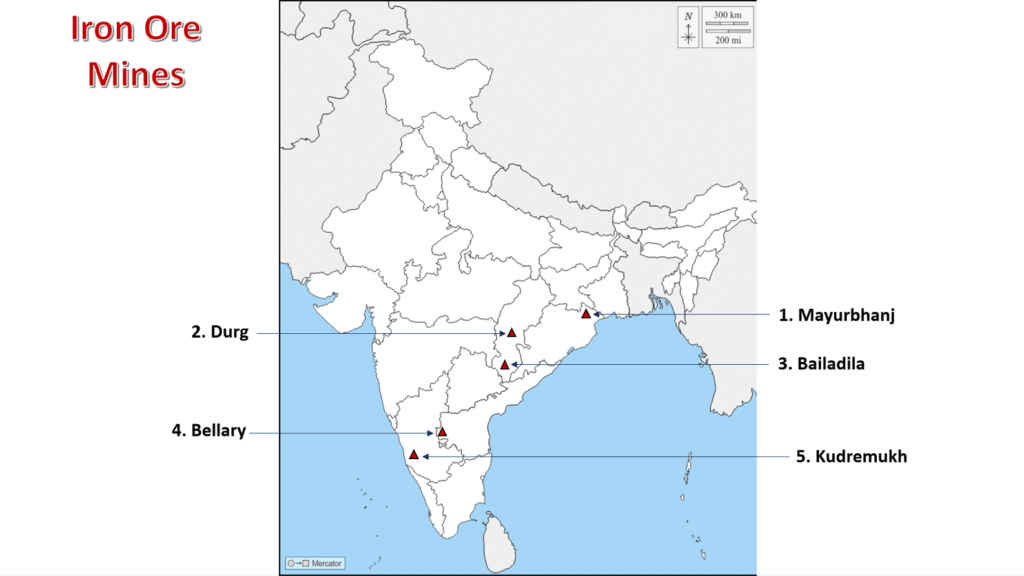
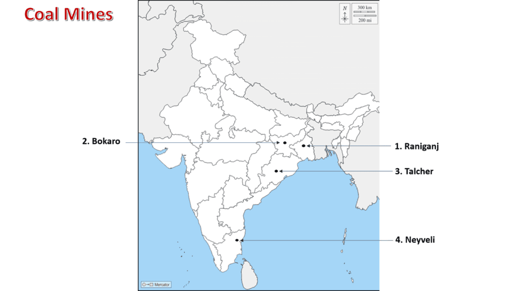
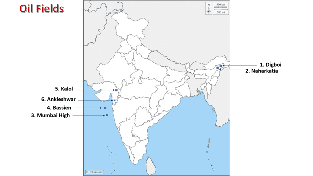
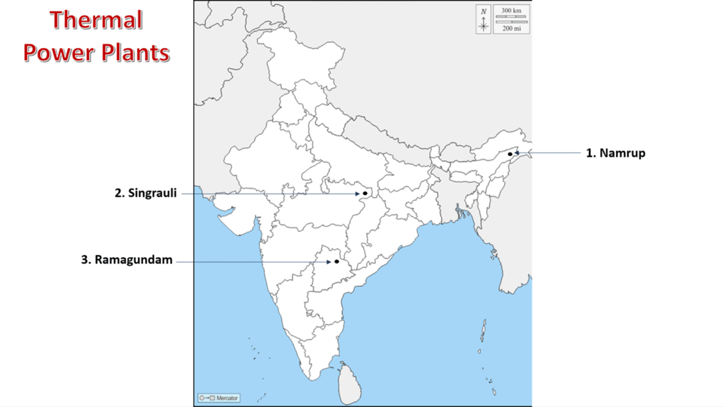
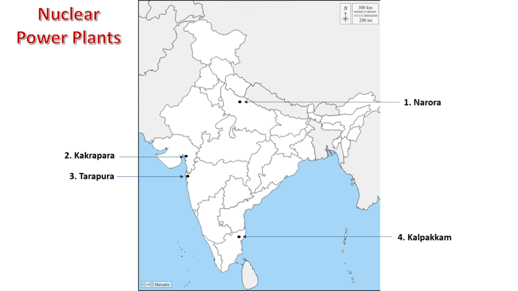
| Chapter 5: Minerals and Energy Resources | Minerals (Identification only) 1. Iron Ore mines a. Mayurbhanj b. Durg c. Bailadila d. Bellary e. Kudremukh 2. Coal Mines a. Raniganj b. Bokaro c. Talcher d. Neyveli 3. Oil Fields: a. Digboi b. Naharkatia c. Mumbai High d. Bassien e. Kalol f. Ankleshwar Power Plants (Locating and Labelling only) 1. Thermal a. Namrup b. Singrauli c. Ramagundam 2. Nuclear a. Narora b. Kakrapara c. Tarapur d. Kalpakkam |
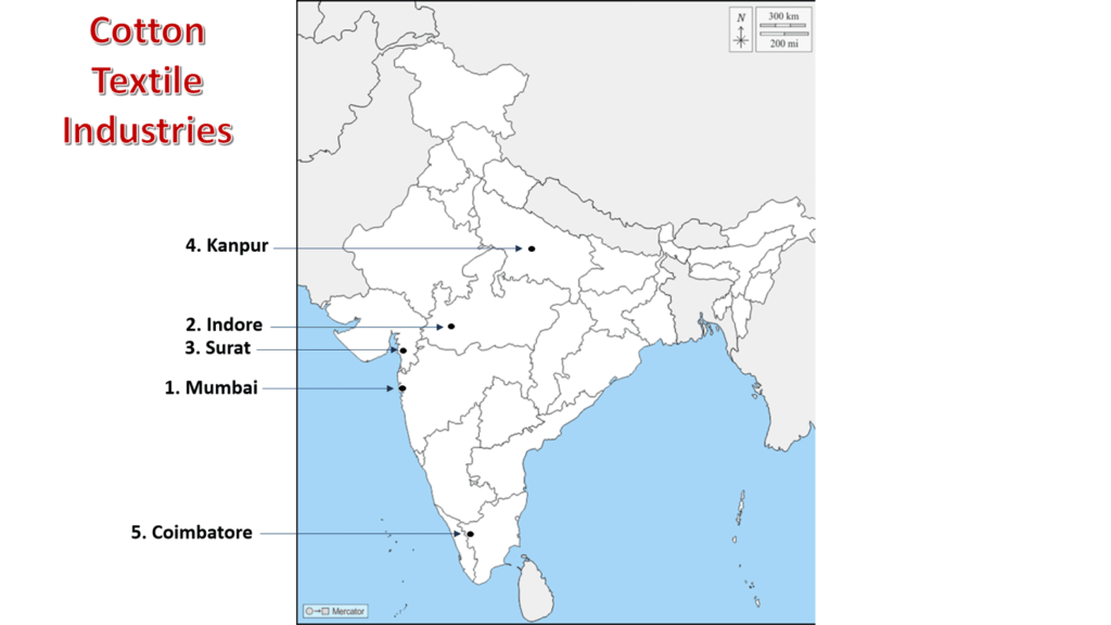
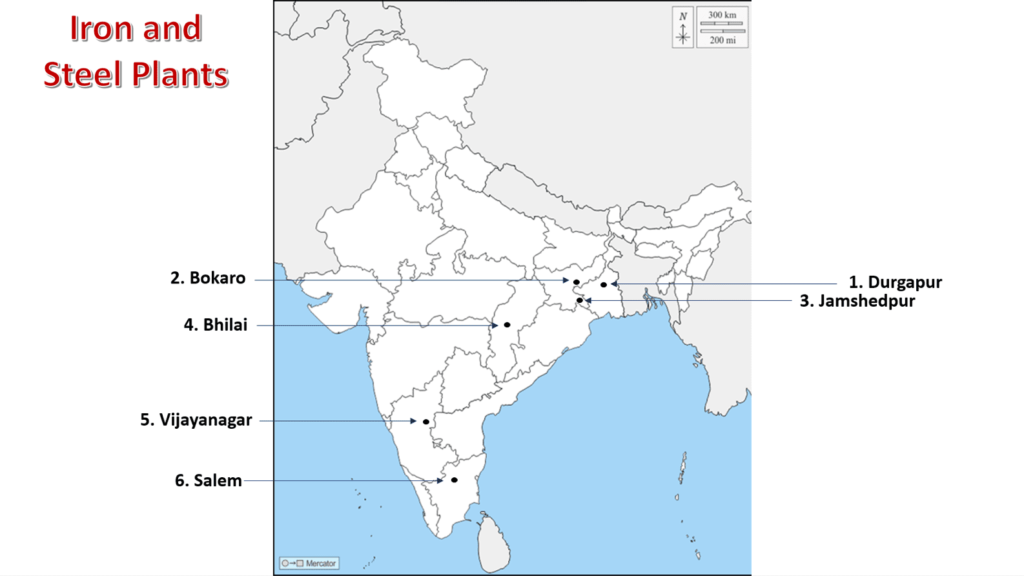
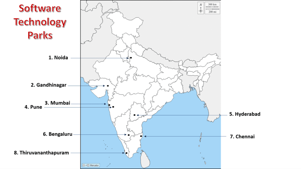
| Chapter 6: Manufacturing Industries | (Locating and Labelling Only) 1. Cotton Textile Industries: a. Mumbai b. Indore c. Surat d. Kanpur e. Coimbatore 2. Iron and Steel Plants: a. Durgapur b. Bokaro c. Jamshedpur d. Bhilai e. Vijayanagar f. Salem 3. Software Technology Parks: a. Noida b. Gandhinagar c. Mumbai d. Pune e. Hyderabad f. Bengaluru g. Chennai h. Thiruvananthapuram |
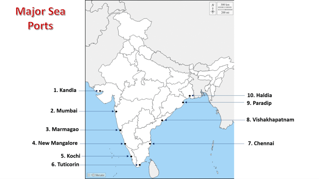
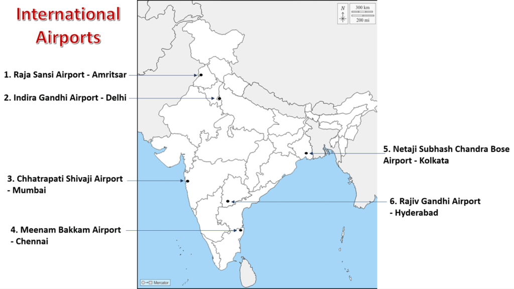
| Chapter 7: Lifelines of National Economy | 1. Major Sea Ports (Locating and Labelling) a. Kandla b. Mumbai c. Marmagao d. New Mangalore e. Kochi f. Tuticorin g. Chennai h. Vishakhapatnam i. Paradip j. Haldia 2. International Airports a. Amritsar (Raja Sansi - Sri Guru Ram Dass Jee) b. Delhi (Indira Gandhi) c. Mumbai (Chhatrapati Shivaji) d. Chennai (Meenam Bakkam) e. Kolkata (Netaji Subhash Chandra Bose) f. Hyderabad (Rajiv Gandhi) |
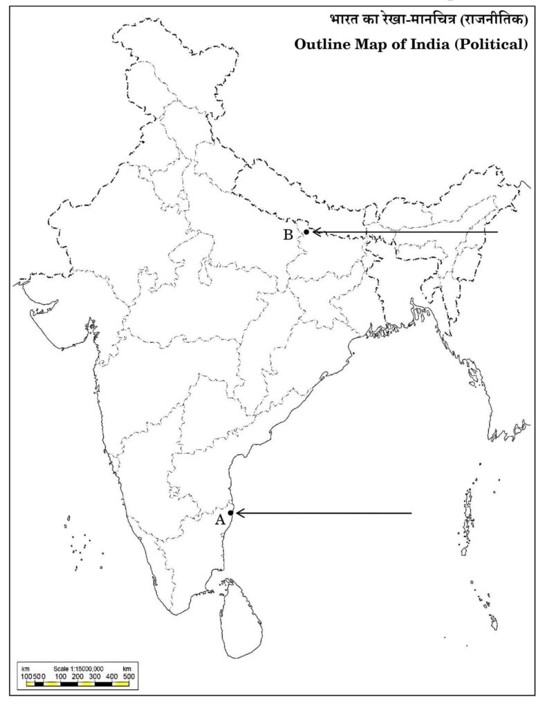
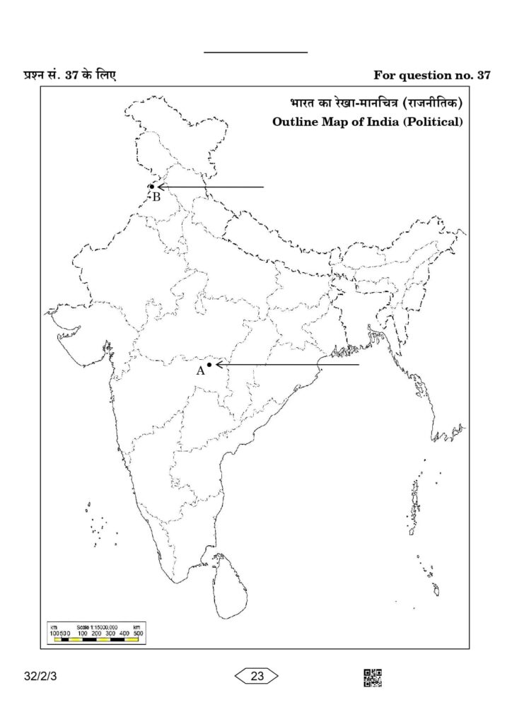
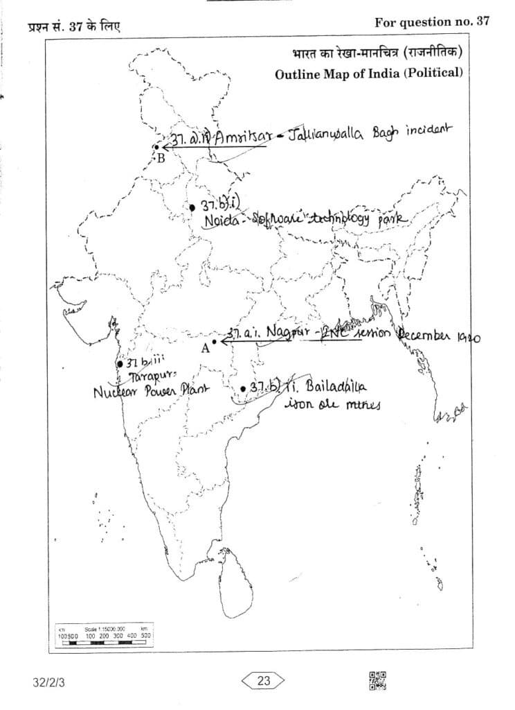
Outline Political Map of India
Outline Map of India (Political)
History
Chapter - 2 Nationalism in India (1918-1930)
A. Indian National Congress Sessions:
- Calcutta (Sep. 1920)
- Nagpur (Dec. 1920)
- Madras (1927)
B. Important Centres of the Indian National Movement
- Champaran (Bihar) - Movement of Indigo Planters
- Kheda (Gujarat) - Peasant Satyagraha
- Ahmedabad (Gujarat) - Cotton Mill Workers Satyagraha
- Amritsar (Punjab) - Jallianwala Bagh Incident
- Dandi (Gujarat) - Civil Disobedience Movement
Geography
Chapter 1: Resources and Development (Identification only)
a. Major soil Types
Chapter 3: Water Resources (Locating and Labelling)
Dams:
- Salal
- Bhakra Nangal
- Tehri
- Rana Pratap Sagar
- Sardar Sarovar
- Hirakud
- Nagarjuna Sagar
- Tungabhadra
Chapter 4: Agriculture (Identification only)
a. Major areas of Rice and Wheat
b. Largest / Major producer states of Sugarcane, Tea, Coffee, Rubber, Cotton, and Jute
Rice
The main rice-producing states are Tamil Nadu, West Bengal (largest producer), Andhra Pradesh, Bihar, Odisha, Uttar Pradesh, etc.
Wheat
The major wheat-producing states are Punjab, Haryana, Uttar Pradesh (largest producer), Madhya Pradesh, and Rajasthan.
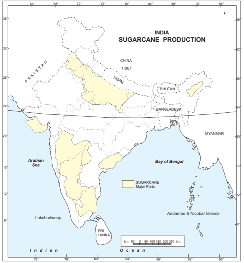
Sugarcane
The major sugarcane-producing states are:
- Uttar Pradesh: Largest producer
- Maharashtra: Second largest producer
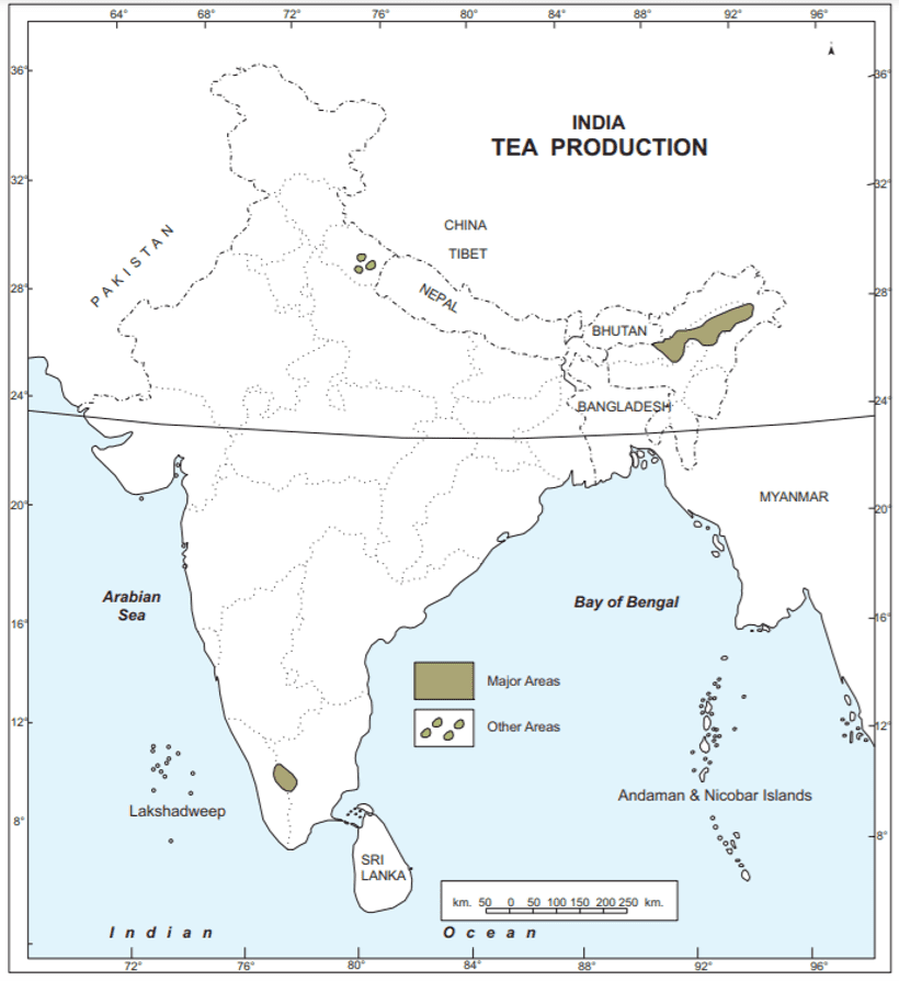
Tea
Major tea-producing states are:
- Assam: Largest producer
- West Bengal: Second largest producer
Coffee
- Karnataka: Largest producer
- Kerala: Second largest producer
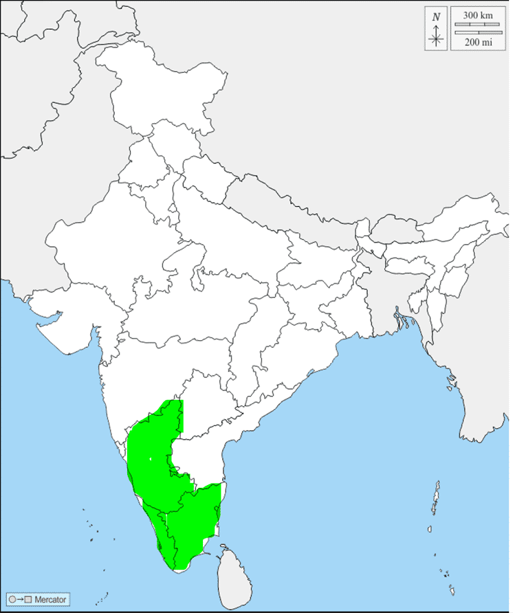
Rubber
- Kerala: Largest producer
Cotton
- Gujarat: Largest producer
- Maharashtra: Second largest producer
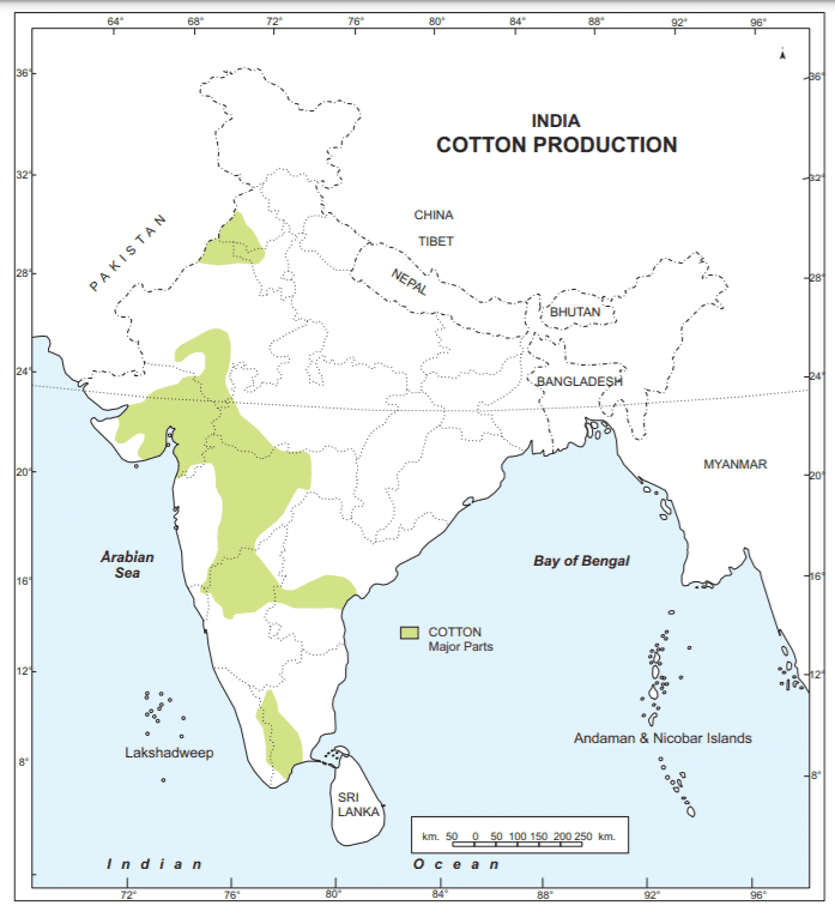
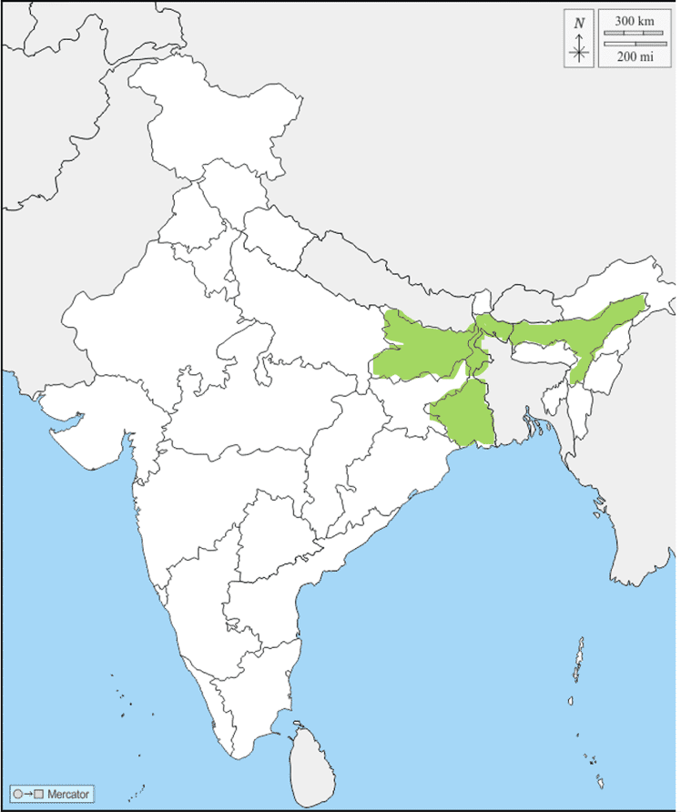
Jute
West Bengal: Largest producer
Chapter 5: Minerals and Energy Resources
Minerals (Identification only)
A. Iron Ore mines
- Mayurbhanj
- Durg
- Bailadila
- Bellary
- Kudremukh
B. Coal Mines
- Raniganj
- Bokaro
- Talcher
- Neyveli
C. Oil Fields:
- Digboi
- Naharkatia
- Mumbai High
- Bassien
- Kalol
- Ankleshwar
Power Plants (Locating and Labelling only)
A. Thermal
- Namrup
- Singrauli
- Ramagundam
B. Nuclear
- Narora
- Kakrapara
- Tarapur
- Kalpakkam
Chapter 6: Manufacturing Industries (Locating and Labelling Only)
A. Cotton Textile Industries:
- Mumbai
- Indore
- Surat
- Kanpur
- Coimbatore
B. Iron and Steel Plants:
- Durgapur
- Bokaro
- Jamshedpur
- Bhilai
- Vijayanagar
- Salem
C. Software Technology Parks:
- Noida
- Gandhinagar
- Mumbai
- Pune
- Hyderabad
- Bengaluru
- Chennai
- Thiruvananthapuram
Chapter 7: Lifelines of National Economy
A. Major Sea Ports (Locating and Labelling)
- Kandla
- Mumbai
- Marmagao
- New Mangalore
- Kochi
- Tuticorin
- Chennai
- Vishakhapatnam
- Paradip
- Haldia
B. International Airports
- Amritsar (Raja Sansi - Sri Guru Ram Dass Jee)
- Delhi (Indira Gandhi)
- Mumbai (Chhatrapati Shivaji)
- Chennai (Meenam Bakkam)
- Kolkata (Netaji Subhash Chandra Bose)
- Hyderabad (Rajiv Gandhi)
(Map Skill Based Question) (2+3=5)
37. (a) Two places A and B have been marked on the given political outline map of India. Identify them with the help of the following information and write their correct names on the lines drawn near them:
(i) The place where the session of the Indian National Congress was held in December, 1920.
(ii) The place where Jallianwala Bagh incident occurred.
(b) On the same political outline map of India, locate and label any three of the following with suitable symbols:
(i) Noida Software Technology Park
(ii) Bailadila Iron-ore mines
(iii) Tarapur Nuclear Power Plant
(iv) Haldia Sea port
Ans.
Download PDF of Class 10 Map Work Social Science

Related posts:
 Class 10
Print Culture and the Modern World Class 10: Important Questions, Easy Answers
Acids, Bases and Salts Class 10 Important Questions and Answers
The Proposal Class 10 MCQ Quiz – Test Your Knowledge
Electricity Class 10 Science MCQ Quiz – Test Your Knowledge
Federalism Class 10 Social Science MCQ Quiz – Test Your Understanding
Class 10 Political Parties MCQ Quiz – Test Your Knowledge
Class 10
Print Culture and the Modern World Class 10: Important Questions, Easy Answers
Acids, Bases and Salts Class 10 Important Questions and Answers
The Proposal Class 10 MCQ Quiz – Test Your Knowledge
Electricity Class 10 Science MCQ Quiz – Test Your Knowledge
Federalism Class 10 Social Science MCQ Quiz – Test Your Understanding
Class 10 Political Parties MCQ Quiz – Test Your Knowledge
 CBSE Class 10 Maths Topper’s Answer Sheet 2024: PDF Download & Analysis
Sir please make video on map work
nahi beta ye abhi impossible hai mai digraj singh rajput hu
Aur mai land singh rajput hun sir mai bhi rajput hun maine apko ekbar superchat dia tha 2 hajar ka land singh ke naam se
Aur mai land singh rajput hun sir mai bhi rajput hun maine apko ekbar superchat dia tha 2 hajar ka land singh ke naam se
ou mai hu baba kela singh chupa
Thanx you so much 😁
sd
Sir I need world map also plz
Where from
i read these map in the morging of tyhe sst exam i managed to get 5 on 5 in maps by overviewing it and in my school teacher show his site on smart board to make learn this map
wow truly inspiring
Baita parilichi Karo is vis bano
Thank you so much alot of efforts vested on on definitely it will help alot of students.
Thank You so much. Alot of effort is vested on this. Definitely it will help alot of students.
Sir I need most important questions of all subjects
what r u studying is all important 🙂
*SERIOUS SUGGESTION*- make *one* clear map with everthing given above, I did it and it made it so much easier1
Question :- Does map questions from cotton textile and Iron and steel plants coming in the board exam (2023-24)
Yuppp
Yes
hey
hey mai I know you?
hii
I DON’T THINK THEY ARE IMPORTANT… BUT READ EVERYTHING
Yep bro
Very useful
Excellent but in 2023-24 Durgapur,, etc r rationalised
I’m seeing day after pre boards 🥲🙃
Nagarjun sagar dam is not in तेलंगाना, that is in Andhra pradesh
can u please provide empty maps to practices with questions for students . its a request
How can you be so dumb
How can you be so egoistic?
Yeah…
Super 💯😊
Make vedio on this
broo go and study the spellings of vedio thn come here
It is available on YouTube
Wrong spelling
Super 💯😊
Make vedio on this map international airport and mining
It’s very poor quality 😠😠
I think you are talking about your phone 📱📱 and also for your shake quality is good , jake new phone le le 🤣🤣
I think you are talking about your phone 📱📱 and also for your shake quality is good , jake new phone le le 🤣🤣🤣😂
Wonderful map points
Thank you so much for this map work sir!
Sir,
How can we download pdf and if there no way to get. So please add a way to download pdf. And can make map according to state also?.
Thank you
How to Download PDF from CBSE Guidance Website
https://youtu.be/zjocgf0LzUM
tysmm for this lovely masterpiece wud like to know the imp points which will com for exam (its js a small suggestion.)
useful
Thanks for it
Very useful..✨💯💯✨
Useful
Bacchon itna karlo 5 number pakka…….
All the best for your tomorrow’s exam.
Team: DSR
Kya sir abhi Tak Jo Jo pardha tha sab dheere dheere ur ja Raha hai kya karu😅
Tu kya sir h kya 😂
thank you sir
diva
WHO IS HAVING SST EXAM ( 6–3–24) ????????????
thank you
YO
haan bhai tera toh ek din pehle karadiya na exam boards walo ne
Thank you so much but I don’t know who make this
Best of luck everyone
So much for preparation map work
Ap sabhi sst ke exam mein 99 le kar aaye
🧿🎀
What will happen if I use pen in map work?
hello everyone
I study all the maps these maps are difficult and easy both but we have taken it over to score good marks in sst .
Bellary is not in Telangana, it is located in Karnataka
good